I’ve been a fan of the OpenStreetMap project for a while, and with good reason. The community-driven project allows community members to directly edit and update the map. Personally, I think of it as the “Wikipedia” of maps. This leads to a detailed, frequently-updated map that I found beat Google Maps to the punch when it came to adding a local landmark.
The Hard Labor Creek Regional Reservoir, a 1,370 acre lake located in Walton County, Georgia, opened to the public in March 2018 after a major project damming up Hard Labor Creek. It’s a fantastic lake with great fishing – but that’s not the focus of this article. Rather, the focus is on the fact that as of August 9th, 2024 — over 6 years later — Google Maps still hasn’t placed the lake on their primary base map.
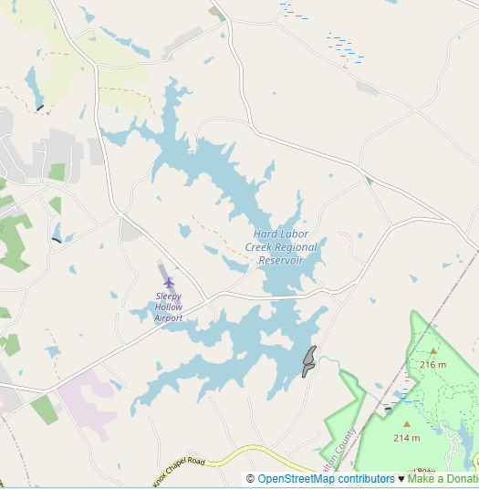
OpenStreetMap has the lake correctly displayed on their base map. Take a look at the first screenshot below. Then, check out the second screenshot showing Google’s base map. Notice anything different?

I know you’re probably thinking this is a minor detail, but it can cause issues for navigation. Here’s a situation that happened to me: the boat ramp for the lake doesn’t have an exact address, and was not visible on Google Maps via search. I tried to eyeball where the boat ramp was located, but I was surprised to see a field of green where a lake should be. This leads to the obvious question, if a lake this size is missing, what else has not been updated on the map?
It appears that other services are spotty on whether or not the lake is displayed. Bing Maps does not have the lake displayed while MapQuest does.
Now, Google Maps and OpenStreetMap do have different audiences. OpenStreetMap does not have the routing functionality, although some services are being developed separately using OpenStreetMap data to perform this task. The “open data” nature of OpenStreetMap makes it useful and adaptable for many different scenarios. In this case, I could have used OpenStreetMap to see right where the boat ramp was located.
To add to the frustration, I have tried to contact Google regarding the missing lake on their base map. Unfortunately I was sent in circles by their support staff leading me to submit “feedback” about the map. Google Maps is in part curated by the community. They rely on businesses and individuals to provide data about their local area. The major difference is that you can submit information to Google, but there is no guarantee that data, no matter how accurate, will be accepted by the Map admins. You have to rely on Google to care about every little thing on the map. And in this case, they couldn’t care less.
This can be contrasted with OpenStreetMap which, while having a community structure, allows more direct edits to the base map. A big benefit of OpenStreetMap is its “open” nature, where just like Open Source software, more eyes and community edits allows for faster delivery and a higher quality product over time. I can only imagine how more useful Google Maps would be if it were open as well. Imagine being able to update route instructions for those annoying times Google Maps tries to get you to turn left into a four lane road with no traffic light. That’s a rant for another day.
Thanks for reading!
